


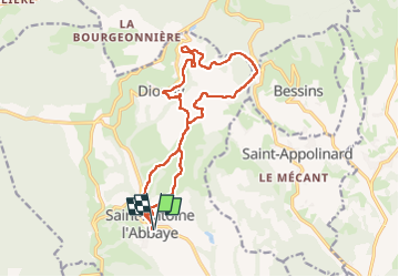
Autour de Saint Antoine l'Abbaye - 26 janv 2025

morganee
User

Length
17.1 km

Max alt
635 m

Uphill gradient
426 m
Km-Effort
23 km

Min alt
349 m

Downhill gradient
427 m
Boucle
Yes
Creation date :
2025-01-26 10:13:25.078
Updated on :
2025-01-26 15:17:41.836
5h03
Difficulty : Easy

FREE GPS app for hiking
 SityTrail
IGN / Geographical institutes
SityTrail Plus
The world is yours!
About
Trail Walking of 17.1 km to be discovered at Auvergne-Rhône-Alpes, Isère, Saint-Antoine l'Abbaye. This trail is proposed by morganee.
Positioning
Country:
France
Region :
Auvergne-Rhône-Alpes
Department/Province :
Isère
Municipality :
Saint-Antoine l'Abbaye
Location:
Saint-Antoine-l'Abbaye
Start:(Dec)
Start:(UTM)
674316 ; 5004564 (31T) N.
Comments